Earthworks & Volume Calculations

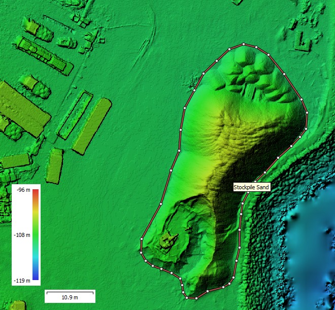
We use RTK-controlled drone surveys to measure earthworks progress, stockpile volumes and cut/fill on highways, wind farms and infrastructure projects. High-density surface models, colour-coded heat maps and CAD-ready outputs give engineers fast, defensible numbers for quantities, mass-haul planning and payment certification.
Deliverables: 3D surface models, cut/fill maps, stockpile volume tables, cross-sections, CAD linework, CSV/Excel volume schedules and PDF reports ready for QS and commercial teams. On request we prepare machine control-ready models for Trimble and Topcon systems.
✔ Regular earthworks progress surveys for highways, wind farms and infrastructure projects
✔ Cut/fill checks against design levels to support setting-out and mass-haul planning
✔ Stockpile volume measurements for quarried materials, aggregates and site-won fill
✔ Volume verification for interim valuations, applications for payment and final accounts
✔ Back-analysis of over- or under-fills to support compensation events and commercial claims
✔ Optimising earthworks balance and haul routes to reduce double handling and haulage costs
✔ RTK-controlled ground and surface models of working platforms, haul roads, batters and slopes
✔ Toe, crest and hinge lines for embankments, cuttings and bunds
✔ Stockpile boundaries and surfaces for individual materials or combined heaps
✔ Drainage features, ponds and settlement areas that influence usable volumes
✔ Control points and check shots tied into your local site grid and vertical datum
✔ Main contractors and earthworks subcontractors who need reliable, repeatable volume checks
✔ Quantity surveyors and commercial teams responsible for valuations and payment certificates
✔ Site engineers and project managers tracking production rates and progress against programme
✔ Designers and engineers who need accurate surfaces for review, optimisation and design coordination
✔ Quarry and material operators who need regular stockpile reconciliation and audit trails
